
FLiteTraX MINI GPS 2G/4G/5G & BLE Tag 5.1-6.3g
FLiteTraX MINI GPS 2G/4G/5G & BLE Tag 5.1-6.3g
FLiteTraX MINI GPS 2G/4G/5G & BLE Tag 5.1-6.3g
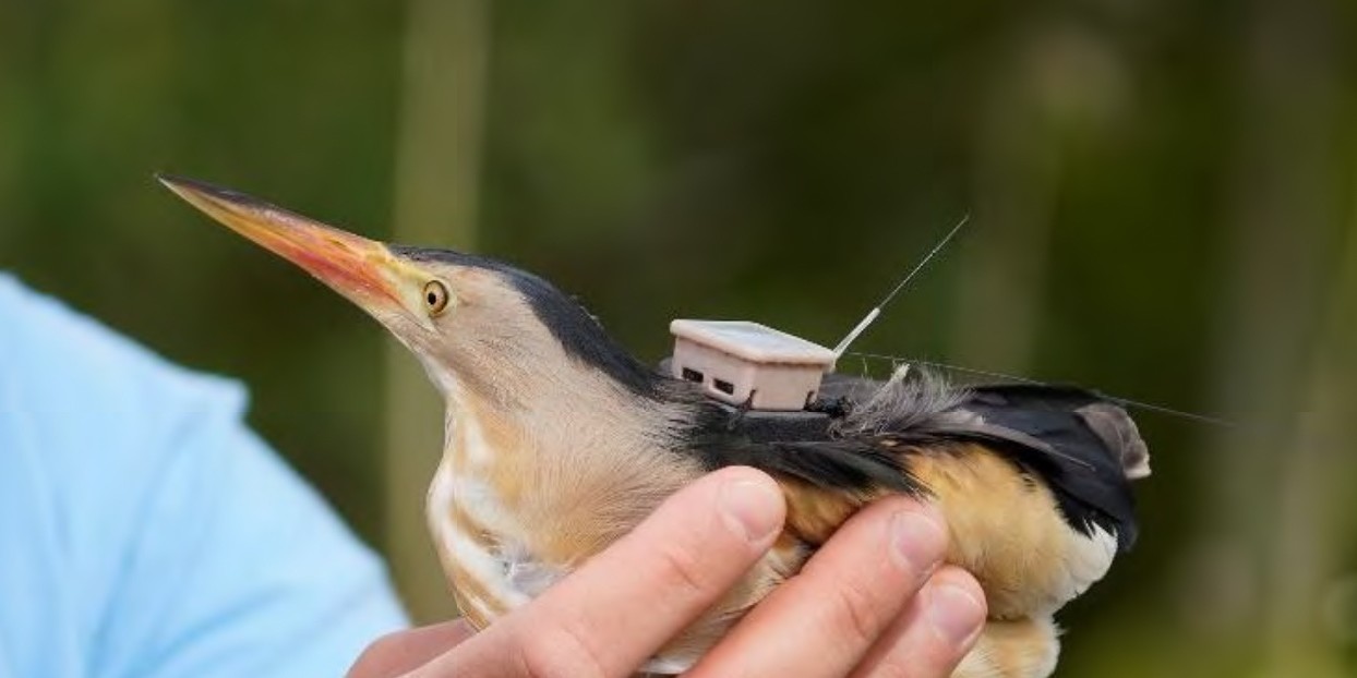
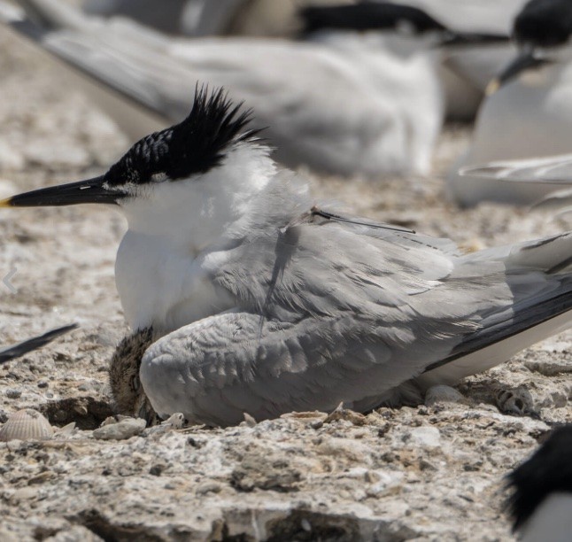
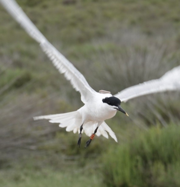
FLiteTraX MINI is small Solar powered GPS tag that uses the 5G cell phone network and long range Bluetooth (INTELINK) to transmit data directly to a mobile phone or to a Bluetooth gateway. Data is uploaded to the cloud server and is accessible to the user through a web page link.
Data upload MINI 2G, 4G or 5G
MINI 2G supports the GSM850, EGSM900, DCS1800 and PCS1900. Data uplink rate 85.6 Kbps/85.6 Kbps
MINI 4G support the standard 4G roaming frequenices. Maximum uplink/downlink data rate:5Mbps/10Mbps
MINI 5G supports both NB-IoT and LTE-M (or called eMTC) frequency bands. We will activate selected bands for devices to be used in different regions.
Maximum uplink/downlink data rate:5Mbps/10Mbps
Data upload MINI BLE Intelink
Transmission method: INTELINK based on Bluetooth 5.0
Maximum uplink/downlink speed: 1 Mbps/1 Mbps
Output power: 8 dBm
Transmission distance: 80~120m with ordinary smart phone; up to 1200m with Debut series gateway products.
|
Specifications |
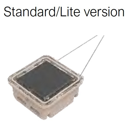
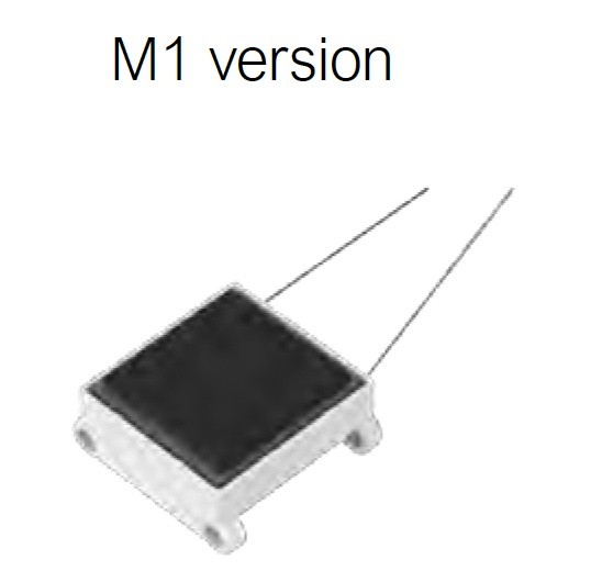
Standard/Lite Version | M1 Version |
| Housing | PC Injection Moulding | Nylon 3D-printing |
| Colour | Light Brown | WHite |
| Weight |
-MINI 4G S 6.3g - 6.5g -MINI 5G S 5.6g - 5.8g |
MINI M1 4G 5.7g - 5.9g MINI M1 5G 5.1g - 5.3g |
| LWD | 20.6 x 20.6 x 11.5mm | 20.5 x 18 x 10.5mm |
| Antenna | External titatnium alloy with protetive coating | |
| Battery | 30 mAh lithium polymer rechargeable battery, with under-and-over-charging protection | |
| Battery Life | Over 300 GPS positions under optimal GPS satellite view at 5-minute interval | |
| Solar Type | GaAs solar unit (30% efficiency) with good performance under weak light | |
| GPS Module |
Precision: CEP(50%)5m Maximum update rate: 10 Hz |
|
| Working Temp | -10°C~60°C (good for cold winter as close to animal body) | |
| Waterproof | IP 68 (The water-proof standard of the M1 version is 10cm underwater for 2 hours.) | |
| Firmware upgrade | Remotely via network, or instantly via BLE INTELINK | |
| Working Schedule | Remotely via network, or instantly via INTELINK | |
| Global Roaming | Support | |
| SMS Function | Support on request | |
| Data Storage |
Logged data will be stored in memory if network is unavailable. - Flash memory: 16 MB - Regular data storage: 460 days at default setting (1h GPS+1h ENV+10 min BHV) - BOOST data storage: 280,000 pieces - ACC data storage: 28,700 pieces |
|
EXTRA FUNCTIONS brought by INTELINK
INTELINK® technology enables remote connection to your MINI (Argos) devices to perform various operations and realize many amazing functions.
To establish such connection, you only need an ordinary smart phone or/and a Debut series gateway device.
*Debut gateways could be a HUB, TAG or QUEST. The connection distance is 30~200m depending on environment.
Tracker Recovery
With ECOTOPIA App, a device and a mobile phone will automatically function as a beaconsystem. The mobile phone will ring if the device is detected nearby. The closer they are, thelouder the ringing sound will be. This provides a convenient way to find lost devices.
Firmware Upgrade & Setting Modification
You can easily upgrade the firmware or change data collection settings and Argostransmission schedules for a device nearby using Ecotopia App.
Remote Data Downloading
MINI (Argos) is capable of collecting much more data than the Argos transmission throughput limitation.
If the bird wearing MINI (Argos) device flies to somewhere near a Debut gateway*, the data stored in the device memory can be automatically downloaded and sent to the cloud server via network connection of the HUB. Then, the researcher can see the data in theiraccounts.
Raw Acceleration Data Collecting
Raw x/y/x acceleration data could be very useful for behavioral research, especially whenthe data can be combined with timestamps, GPS, environmental data, and the bird’sactivity rhythm. However, the raw data can seldom be obtained due to its large size.
With INTELINK, you can not only download the raw data from memory, but also obtain real-time raw acceleration data by connecting a mobile phone to a MINI device.
In-situ Modeling
During the process of obtaining real-time raw data described as above, you can also markthe data with behavior tags. Ecotopia App provides comprehensive tools for In-situmodeling, which includes real-time x/y/z acceleration visualization and data downloading,video shooting, and behavior tagging. All these data will be combined under thetimestamps and saved for later verification and analysis.
With the help of Druid’s AniAct® behavior algorithm platform, you will be able to generateacceleration-based behavior algorithm for different species.
Furthermore, such algorithm can be loaded into the tracker and be conducted on board.Then, the tracker will be able to send back continuous computed result of behavior tagsinstead of discontinuous raw data. This will expand the data dimensions and bringbreakthrough on bird research and ecology conservation.
DATA TYPES
-
GPS: longitude, latitude, altitude, geoid height, course, GPS satellite quantity
-
ENV: light intensity, temperature, inner air pressure, voltage
-
BHV: ODBA (overall dynamic body acceleration)
-
ACC: x/y/z acceleration data at 25 Hz (by default)
DATA COLLECTION MODES
User can choose from the following data collection modes, and specify the related parameters to suit the condition and objective of the study.
Regular Mode
- GPS interval: 5 min ~1 day
- ENV interval: 5 min ~1 day
- ODBA interval: 10 min/30 min
- ACC interval: 25 Hz, 3 seconds in every 10 min (by default)
- Transmission interval: 5 min ~1 day
- Above ranges can be set on webpage/App. If other settings are required, please contact us.
On-Time Mode
- Transmission: Up to three times at fixed hours per day (such as 13:00/14:00/18:00)GPS/ENV/BHV:
- Regular-interval model or on-time model follow each transmission
Sleep Mode
This mode is to save power by deactivating certain type of data collection for:
- a certain period (from minutes to months)
- a regular period each day (a maximum of 16 hours)
Raw Acceleration Data Collecting
Raw x/y/z acceleration data could be very useful for behavioral research, especially whenthe data can be combined with timestamps, GPS, environmental data, and the bird’s activityrhythm. However, the raw data can seldom be obtained due to its large size.
With INTELINK, the user can not only download the raw data from memory, but also obtain real-time raw acceleration data by connecting a mobile phone to MINI.
INTELLIGENT FREQUENCY OPTIMIZATION (BOOST)
The BOOST function intelligently increases the frequency for data collection when certain conditions are met (good charging, fast movement, etc.).
The default setting is as below:
- Frequency Optimization: GPS at every 10 minutes
- Flight Detection: GPS at every 5 minutes
With BOOST, the device portrays detailed movement tracks and attempts more frequent data transmission without manual intervention, keeping long-term energy balance and avoiding the possibility of battery drain caused by radical settings during bad weather.
Who is using our GPS collars and tags?
Sign Up For Our Newletter
For offers and the latest news on our case studies